Agricultural Intelligence and Workflow Management | CamoAg

Unlock the Power of Agricultural Land and People Intelligence

Streamline client data on farm operations, ownership and value to sell more, boost efficiency, and master your market.

Gain a Competitive Edge With Deeper Client Insights

CamoAg’s Platform gives agribusiness professionals comprehensive, real-time customer insights to make informed decisions. Whether you are an ag lender, agribusiness appraiser, broker, or otherwise related to rural land and producers platform delivers the data you need to grow your business, streamline workflows, and reduce risk.

Explore Our Agricultural Data

CamoAg integrates various data types, connecting data across data types and sources to provide users with a complete view of farmland, ownership, and operations.  Our data is nationwide, temporal, and geospatial. 

Want to enrich customer data? CamoAg can match and enrich your data instantly either on a one-time basis or on an ongoing basis.

KEY FEATURES
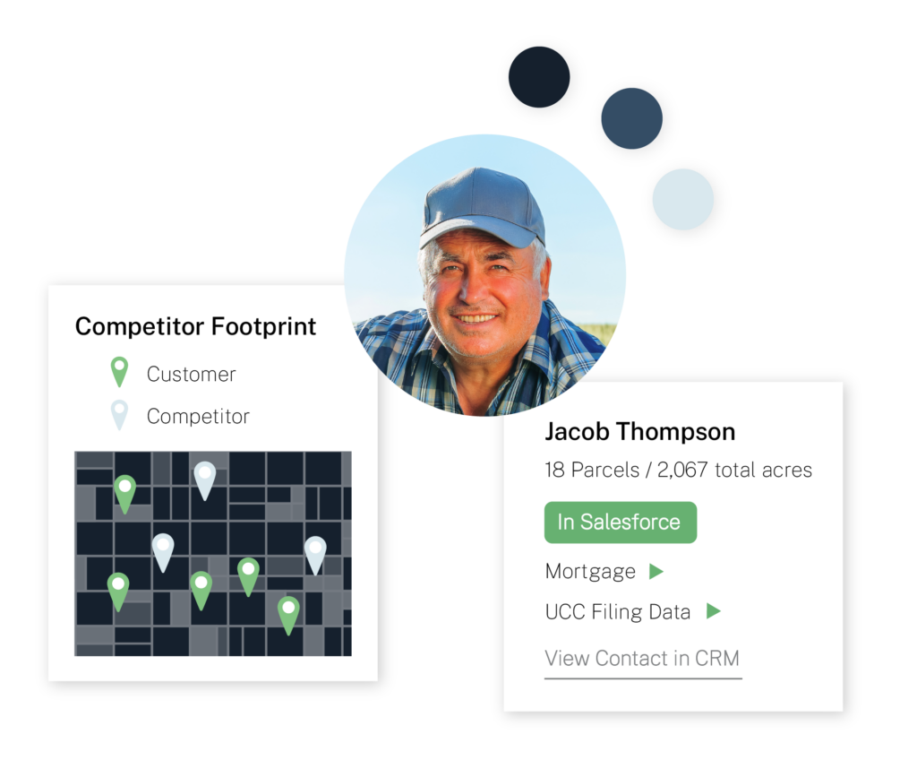
Producers & Operators

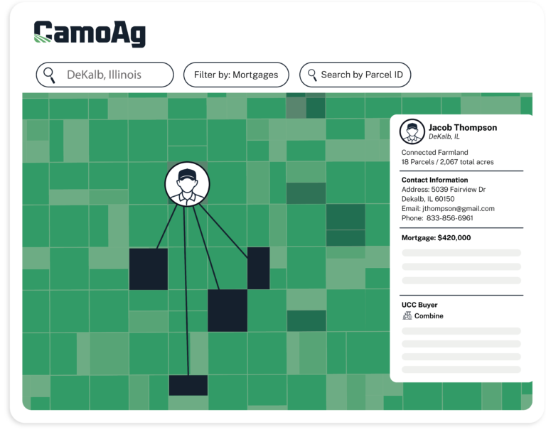
Data on farm operations, including land owned, government payments, associated contacts, recent land purchases & sales, financed equipment purchases, and more.

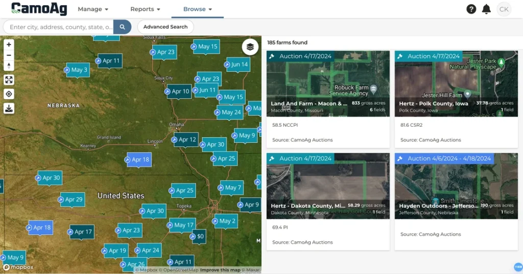
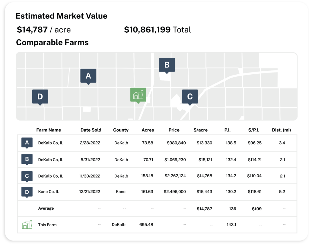
Farmland Transactions

Land sales transaction data geospatially matched to the parcel(s), and market analytics data, including the largest buyers and sellers of land, and market trend data, including value and volume of transactions.

Nationwide Aggregation

Aggregated data from across the U.S., providing insights into land ownership and market trends.

Land Ownership

Ownership data for every parcel in the US, including tax pins, parcel boundaries, assessor data*, crop history, and soil data. Aggregated ownership data that aggregates land holdings across ownership groups, entities, and states and maps land holdings to the individual parcels/tax pins.
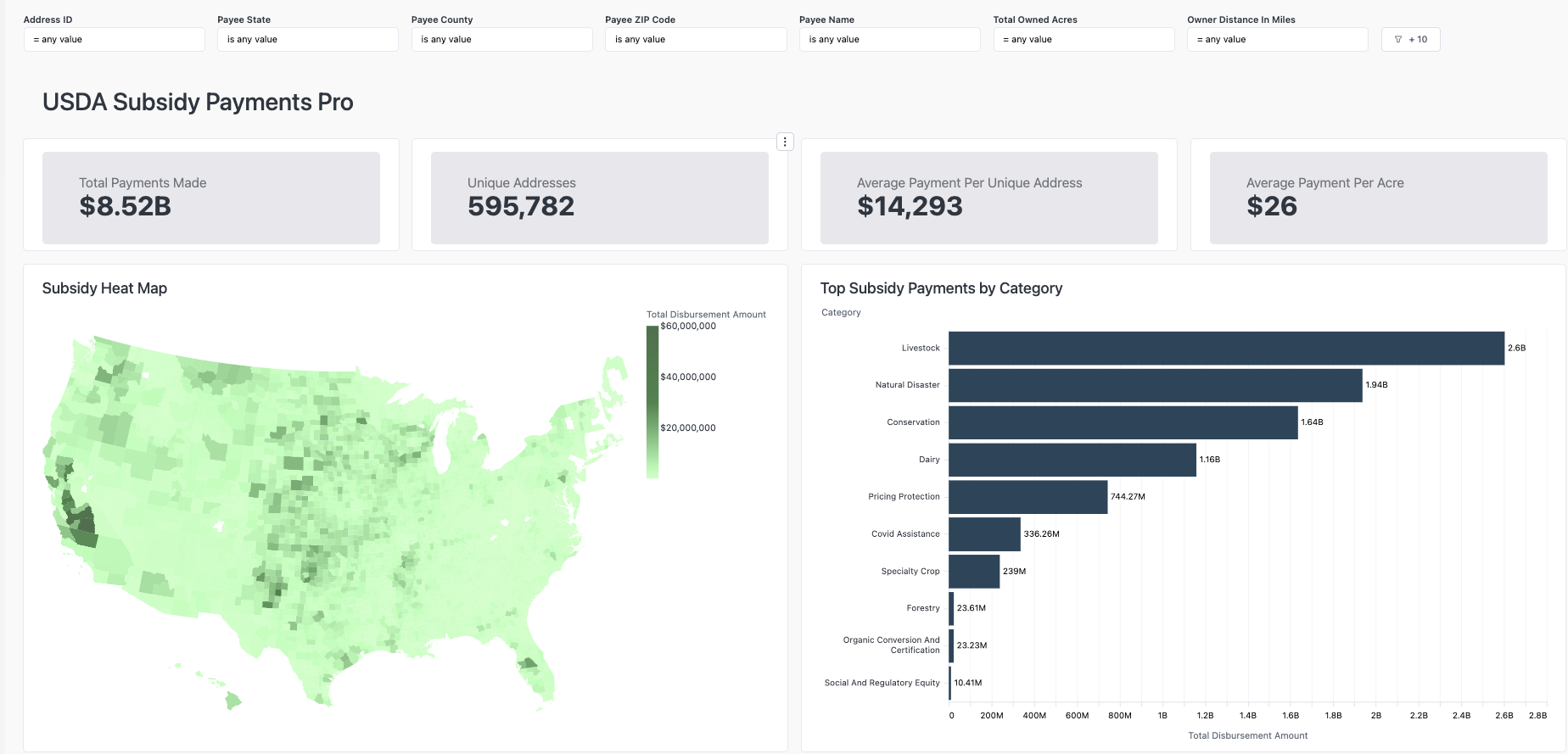
USDA Subsidies

Information on government subsidies linked to farming operations.

Geospatial Mapping

Visualizes land boundaries, crop health, and terrain features for better land management.

Financial Data

Nationwide mortgage data on land across the US geospatially matched to the parcels collateralized as part of the mortgage, in partnership with Fusable, access to nationwide UCC data on agricultural equipment.

First-Party Data Integrations

Leverage your own data combined with CamoAg’s datasets to get a fuller picture.

How Agribusinesses Use Our Data

Find new customers and enrich your prospect database

Segment your target audience using detailed ownership, parcel, and crop history data. Build targeted marketing lists and execute digital campaigns. By integrating CamoAg with your CRM, you can ensure real-time, accurate insights into prospects and customers.

Simplify Your Real Estate & Appraisal Workflows

With access to detailed land sales, auction results, and historical crop data, appraisers can enhance accuracy and speed in market evaluations. Use topographic and flood data to assess potential risks and property usability.

Enhance Ag Lending & Evaluation Process

Leverage land ownership data, parcel information, mortgage records, and subsidy payments to verify loan eligibility and assess collateral risks. CRM integration ensures seamless access to borrower profiles.

KEY FEATURES

Unlock Better Loan Prospects

CamoAg’s Client Intelligence tool empowers agricultural lenders to identify and qualify potential loan applicants more effectively. By providing valuable insights and a deeper understanding of clients, this solution enhances marketing outreach efforts and enables more informed decision-making.

Map, Sort, and Search Current & Prospective Customers
Land Owner Data

Nemo enim ipsam volupta quia voluptas sit asperna.

Land Owner Data

Nemo enim ipsam volupta quia voluptas sit asperna.

Map, Sort, and Search Current & Prospective Customers
Land Operator Data

Nemo enim ipsam volupta quia voluptas sit asperna.

Land Operator Data

Nemo enim ipsam volupta quia voluptas sit asperna.

Map, Sort, and Search Current & Prospective Customers
Land Operator Data

Nemo enim ipsam volupta quia voluptas sit asperna.

Land Operator Data

Nemo enim ipsam volupta quia voluptas sit asperna.

How Agribusinesses Use CamoAg Data

DATA INTEGRATION & ENRICHMENT

Seamlessly Connect CamoAg’s Data with Your Existing Tools

Seamlessly integrate CamoAg’s data with your CRM, Appraisal Software or other internal systems. Enrich your customer profiles with up-to-date ownership, parcel, and operator data, ensuring accurate insights and more informed decision-making.

GIS-BASED MAPS

Get a Full 360° View of Land, Producers, and Operations

Use our GIS platform to visualize parcels, crop history, and ownership data while uncovering new customers and understanding your market. With custom layers like satellite imagery, topography, transmission lines, and FEMA flood data, get real-time insights into land assets, producers, and market opportunities for smarter decision-making.
camoag ag insights

REPORTS

Turn Insights into Action with Dynamic Ag Data Reports

Harness the power of dynamic ag data reports to turn raw information into actionable strategies. Explore key data points like land sales, ownership, valuations, and market trends. Build target lists and gain insights into your operations and market. Tailored to your needs, these reports help you make smarter decisions, optimize sales, and drive business growth.

COMP TOOL

Build Comps Faster and More Accurately

Quickly generate precise land valuations using real-time sales, acreage, and ownership data. Perfect for real estate brokers to create and share CMAs with clients and appraisers and investors to make informed decisions about buying and selling land with public and private sales data.
real estate comp tool CMAs

Let's chat.

Integrate your customer data and gain actionable insights that drive smarter decisions, better marketing, and more effective sales strategies. Get Started Now and transform your data into a powerful tool for growth.