

A Comprehensive Guide to Enhancing Efficiency and Accuracy in Rural Property Appraisals using CamoAg and AgWare
This article highlights effective practices for utilizing CamoAg’s software alongside AgWare’s appraisal solutions for rural appraisers. Since announcing their partnership in the fall of 2023, AgWare and CamoAg have been collaborating to enhance the compatibility of their software solutions, aiming to boost the productivity of appraisal teams and the quality of the data they generate.
Without these advanced tools, the rural land appraisal workflow is often time-consuming and manual, relying heavily on disparate data sources and extensive paperwork, which can slow down decision-making and increase the potential for errors.
This collaboration seeks to expedite the appraisal process, thereby increasing revenue for appraisers and reducing turnaround times for lenders.
The New Rural Land Appraisal Workflow using AgWare and CamoAg
Here is a breakdown of how appraisal teams would leverage each solution in their appraisal workflow.
AgWare’s software is renowned for its capability to produce USPAP-compliant appraisals for rural properties, encompassing the necessary forms, fields, reports, and data organization.
CamoAg’s platform, on the other hand, is a geospatial intelligence tool that aids appraisers by:
AgWare’s solutions are designed to generate the appraisal report, while CamoAg’s platform provides the geospatial data, such as property boundaries and soil maps, that feed into the AgWare system. This synergy allows appraisers to work more effectively.
Creating Subject Farms for Rural Land Appraisals
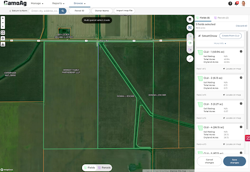
A subject farm, in the context of land appraisal and geospatial analysis platforms like CamoAg, refers to a specific parcel or tract of agricultural land that is being evaluated or appraised. It is the primary focus of the appraisal process, where various data points such as ownership, land use, soil quality, and other relevant characteristics are collected, analyzed, and documented.
The term “subject farm” distinguishes this particular piece of land from comparable sales (comps) or other properties being analyzed for valuation purposes. In appraisal software, creating a subject farm typically involves mapping the property, gathering and inputting detailed information about it, and possibly sharing this information with team members for collaborative analysis and appraisal completion.
CamoAg simplifies the process of creating a subject farm with its comprehensive plat map, parcel and owner search capabilities, and robust mapping tools. It offers features for easy organization, sharing, and storage of property reports, photos, and videos related to a subject farm.
Farm Mapping features include:
After a subject farm is created it can be synced to AgWare Maven to complete the appraisal. You can read more about the Farm Import process on AgWare’s website here.
Pro Tip: CamoAg’s mobile-responsive page facilitates onsite uploads of videos and photos, syncing automatically with the subject farm in Maven.
Sharing and Collaboration on Subject Farms with Appraisal Teams and Stakeholders
CamoAg offers a versatile platform for sharing and collaboration within your organization, significantly improving the efficiency and speed of the appraisal process and visibility into your portfolio. Here’s how
Understanding Private Comps in CamoAg
CamoAg introduces the capability to create a comparable sales record that remains exclusive to your organization. This feature ensures that sensitive or preliminary information about a sale remains confidential, accessible only to authorized members within your team.
By leveraging CamoAg’s functionality to create private comps, you’re equipped to manage and analyze sales data with a level of detail and confidentiality unmatched by traditional methods. This process not only enhances your understanding of market dynamics but also strengthens your organization’s competitive edge in the appraisal landscape.
Creating Verified Comp Sales for Rural Land Appraisals
Comp sales can be created from scratch or by copying public sales from the Sold Farms map, with the latter method involving the selection and customization of publicly available data. This integration ensures that all relevant reports and documents are synchronized with the AgWare sales record.
A verified sale in the platform requires at minimum:
However, much more data can be captured in the CamoAg platform and much of it is captured at the creation of the farm if available:
Pro Tip: Already have an extensive database of comps in AgWare? AgWare’s existing database of comps can be seamlessly integrated into CamoAg via an API, maintaining synchronization between the two platforms.
Have a different database stored in excel or another format? Talk to us about our tools to import your existing database into CamoAg!
Create a Verified Comp Sale from Scratch in CamoAg
This approach is particularly valuable when you possess early insights into a sale, information that hasn’t yet been recorded by the county or made public.
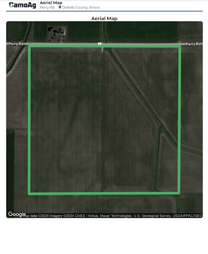
Aerial Imagery: Include detailed aerial photos of the property.
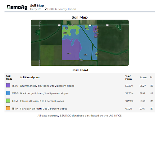
Soil Maps: Add soil composition and quality maps.
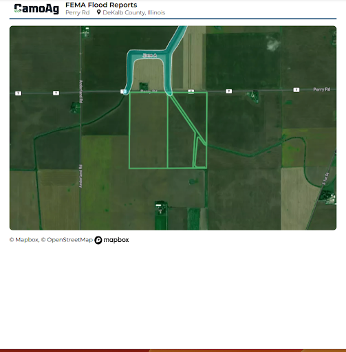
FEMA Flood Maps: Incorporate flood risk assessments.
5. Synchronize Documents: Ensure all added reports are stored in the documents folder and synchronized with the AgWare sales record for a comprehensive appraisal.
This approach allows you to effectively use private or early data to create accurate and detailed comp sales in CamoAg, enhancing the appraisal process with in-depth analysis and documentation.
Detailed instructions for creating a comp sale can be found here.
Pro Tip: Aware of an upcoming auction? You can create the farm and add all of the details prior to the auction and save the sale as a draft, then when the farm sells simply add the information of the buyer and the final sale price. Several parcels being auctioned by the same seller on the same day? Create the first tract to be auctioned and copy that “sale” to avoid duplicate data entry by simply updating the tract, sale price, and buyer information.
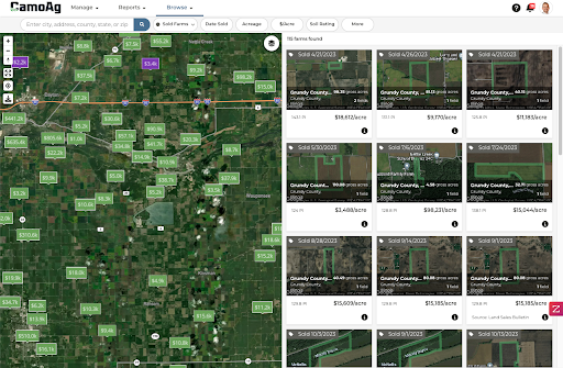
Create a Verified Comp Sale from Public Sales
A streamlined approach to enriching your comp sales database involves utilizing public sales data accessible through our Sold Farms map. This feature consolidates information from multiple sources, visually representing farms on an interactive map for easy identification and selection.
What’s Next?
CamoAg and AgWare are committed to advancing the rural land appraisal process through strategic improvements such as:
Leveraging CamoAg’s platform alongside AgWare enables appraisal teams to improve their operational efficiency. This facilitates the discovery, mapping, and analysis of comp sales, streamlining the creation of subject farms and the verification of comp sales. The seamless integration ensures a reduction in manual data entry, transforming time into savings and directly contributing to your bottom line. Ultimately, the collaboration between CamoAg and AgWare is designed to optimize the appraisal process, saving you valuable time and increasing profitability.
About CamoAg
CamoAg is a leading provider of geospatial intelligence solutions, designed to empower rural land appraisers with advanced mapping, data analysis, and collaboration tools, streamlining the appraisal process and enhancing accuracy.
About AgWare
AgWare specializes in creating USPAP-compliant appraisal software for rural properties, offering a robust suite of tools for data organization, report generation, and comprehensive analysis to meet the specific needs of the appraisal industry.