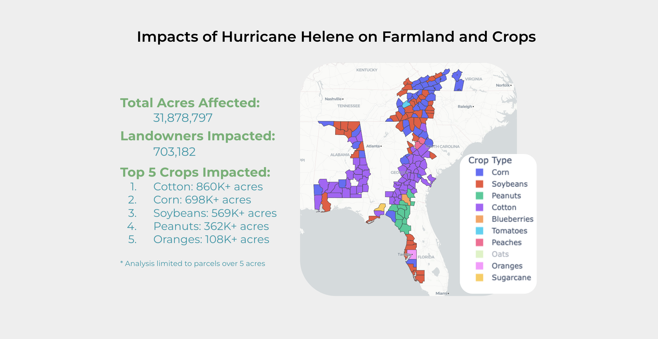
In the wake of Hurricane Helene, many in the agricultural community have been taken aback by the widespread damage across key farming regions in the Southeast. With nearly 32 million acres impacted and over 700,000 landowners affected, the devastation has been profound, particularly for those growing high-value crops like cotton, corn, and soybeans. As agricultural professionals and landowners begin to assess the damage, it’s clear that recovery will take time and significant resources.
At CamoAg, we harness the power of agricultural intelligence to bring clarity to these situations, providing critical insights through data mapping and analytics. Leveraging our platform, we took a closer look at the FEMA disaster zones and assessed the potential damage to land and crops. Below is a summary of the impact, including the top five crops affected:
Total Acres Affected: 31,878,797
Landowners Impacted: 703,182 (focusing on parcels over 5 acres)
Top 5 Crops Impacted:
Cotton: 860,000+ acres
Corn: 698,000+ acres
Soybeans: 569,000+ acres
Peanuts: 362,000+ acres
Oranges: 108,000+ acres
Our detailed mapping also identifies the most affected crop in each disaster-declared county, highlighting how different regions have suffered. While cotton was the hardest hit overall, crops like peanuts and oranges also experienced significant losses, impacting farmers’ livelihoods and agricultural supply chains.

How CamoAg Can Help During Disaster Recovery
The scale of damage in events like Hurricane Helene underscores the importance of having access to timely, accurate data to guide recovery efforts. With CamoAg, agricultural businesses, landowners, and organizations can take advantage of our platform’s robust features to gain insights into impacted regions and individual parcels. When fully integrated, CamoAg will be able to map the impact back to specific customers, allowing businesses to directly connect and support their affected clients in real time.
Our Agriculture Intelligence Platform is designed to empower agricultural businesses to:
Visualize Affected Areas: Our geospatial mapping capabilities can show the extent of the damage to farmlands, highlighting crops and regions impacted by severe weather events.
Analyze Crop and Landowner Data: CamoAg provides granular data on crops, ownership, and land parcels, enabling businesses to tailor recovery strategies to the specific needs of their customers.
Optimize Outreach and Support: By integrating customer and parcel data, our platform helps agricultural businesses and lenders quickly identify affected landowners and provide them with timely assistance and resources.
As businesses in the agricultural industry continue to grapple with the fallout from this disaster, the ability to quickly access and analyze data will be crucial to minimizing losses and supporting recovery. If you believe CamoAg can help your organization respond to severe weather events or better manage customer relationships, reach out to us today.
At CamoAg, we are committed to helping agricultural businesses navigate both day-to-day operations and unforeseen challenges like Hurricane Helene, with data-driven solutions that ensure you have the insights needed to grow and thrive—even in the face of adversity.